New Zealand Severe Weather – Red Warnings Across Regions
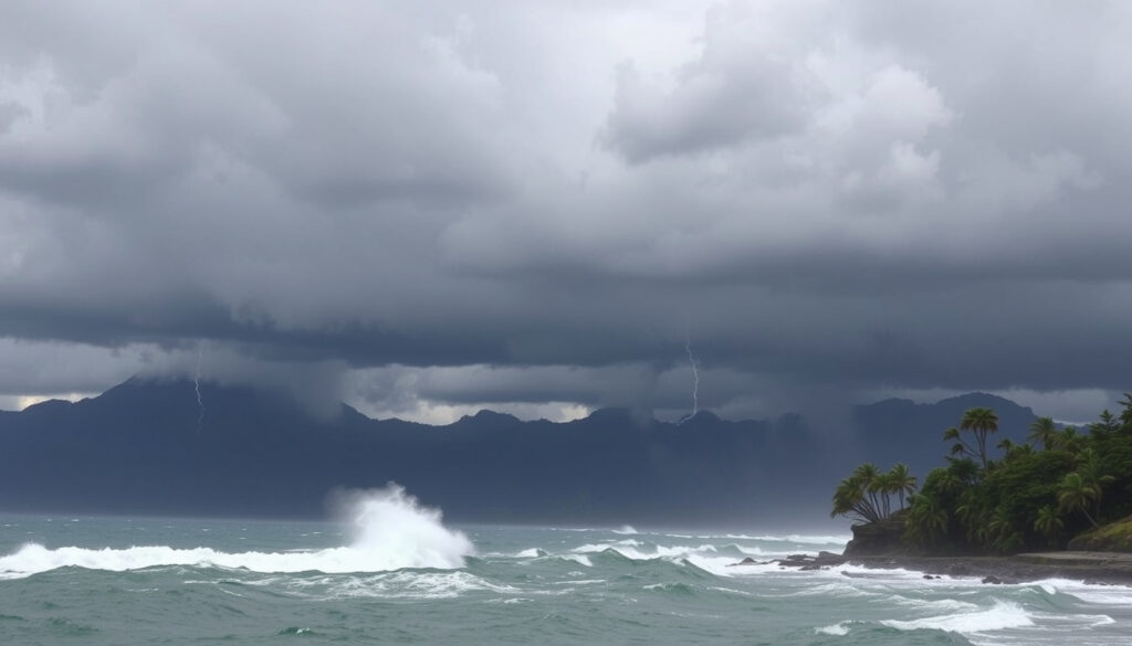
A powerful multi-hazard storm system is sweeping across New Zealand, bringing extreme rainfall, damaging winds, and widespread flooding concerns. MetService has deployed its highest warning tier—red alerts—for parts of the country, while civil defence authorities have declared states of emergency in multiple regions. The event, driven by a subtropical low pressure system originating from the Tasman Sea, is being monitored closely as conditions continue to deteriorate across both islands.
The storm has been described by meteorologists as a “monster” system affecting areas from Cape Reinga to South Canterbury. Emergency management officials are urging residents in affected zones to complete evacuation preparations immediately and avoid all contact with floodwaters. The timing coincides with the tail end of New Zealand’s summer season, when many communities remain engaged in outdoor activities and holiday travel.
This represents the third red weather warning issued by MetService this year, underscoring the severity of the current event. Authorities emphasize that conditions remain fluid, with additional regions potentially facing upgraded warnings as the system tracks southeastward. Residents are advised to monitor official channels for the most current information.
Is There Severe Weather in New Zealand Right Now?
Active severe weather warnings are currently in effect across extensive portions of New Zealand. MetService’s tiered alert system is operating at maximum intensity, with red warnings indicating imminent threats to life in several regions. The situation is evolving rapidly, and officials warn that conditions could deteriorate further before any improvement occurs.
- Red heavy rain warnings active for eastern Northland with threat to life from dangerous rivers and significant flooding
- Orange warnings extend across Coromandel Peninsula, Bay of Plenty, Tasman, Marlborough, Westland, North Otago, and South Canterbury
- Strong to gale northeasterly winds affecting Auckland, Northland, and Banks Peninsula
- Subtropical low pressure system lingering over the Tasman Sea, drawing moisture-laden air into the country
- Severe thunderstorm criteria met: ≥25mm/hour rainfall, ≥20mm hail, or ≥110km/h wind gusts possible
- Third red warning issued by MetService this year, indicating exceptional severity
| Metric | Details |
|---|---|
| Red Warnings | Eastern Northland (4pm Thursday – 4am Friday) |
| Orange Warnings | Coromandel, Bay of Plenty, Tasman, Marlborough, Westland, North/South Canterbury |
| Wind Warnings | Auckland, Northland, Banks Peninsula (gale-force northeasterlies) |
| Rainfall Potential | Up to 90mm in North Otago/Canterbury; higher amounts in exposed eastern ranges |
| Peak Wind Gusts | Severe thunderstorm criteria: ≥110km/h in convective cells |
| System Type | Subtropical low (possibly ex-tropical cyclone influence) |
| Duration | Heaviest impacts expected Thursday through Friday |
| Death Toll | Not yet confirmed in available data |
| Emergency Declarations | Northland: 7-day State of Emergency |
| Thunderstorm Risk | Severe criteria possible with heavy convective bands |
What Areas Are Affected by Severe Weather in New Zealand?
The storm system is impacting nearly the entire country, though the northern and western regions face the most immediate threats. Emergency management agencies have activated coordinated response protocols across multiple territorial authorities. The geographic breadth of this event sets it apart from typical weather systems that usually affect more localized areas.
Northland and Whangārei
Northland has borne the initial brunt of the storm, with civil defence authorities declaring a seven-day State of Emergency. The eastern portion of the region is under red heavy rain warnings, with meteorologists warning of dangerous river conditions, significant flooding, and land slips. Residents in low-lying areas have been advised to complete evacuation plans and move to higher ground. Officials stress that contact with floodwaters poses serious health and safety risks.
Upper North Island
The broader upper North Island—including Coromandel Peninsula, Bay of Plenty, Auckland, and remaining Northland areas—remains under orange heavy rain warnings with high probability of upgrade to red status. Heavy convective rain bands are developing across these regions, increasing the likelihood of rapid water accumulation. Strong to gale-force northeasterly winds are accompanying the rainfall, creating additional hazards for infrastructure and outdoor activities. Scattered rain showers are expected to become more persistent as the system deepens.
South Island Regions
South Island territories from Tasman through to South Canterbury face significant rainfall accumulations, with up to 90 millimetres possible in North Otago and Canterbury areas. Gale-force winds are affecting the Banks Peninsula coastline specifically. Morning drizzle that initially affected these regions is developing into heavier precipitation, with conditions expected to intensify through the evening hours.
Beyond immediate flooding, authorities are monitoring for potential landslides, storm surge along coastal areas, debris mobilization in flood zones, and infrastructure damage. Road closures may be implemented with limited notice as conditions deteriorate. Wellington and Christchurch are experiencing strong northeasterly winds and persistent evening rainfall that could develop into heavier precipitation.
What Caused the Severe Weather in New Zealand?
The current extreme weather event originates from a subtropical low pressure system positioned over the Tasman Sea, west of New Zealand. This weather pattern is drawing significant moisture from the warm Tasman waters, channeling it directly into the country. The system bears characteristics consistent with an ex-tropical cyclone, with some meteorological references suggesting influence from Cyclone Vaianu or a similar nearby system making transition from tropical to subtropical classification.
Understanding the Weather Mechanism
Subtropical low pressure systems form when tropical cyclone remnants interact with mid-latitude weather patterns, losing their tropical characteristics while retaining significant moisture and energy. These hybrid systems can produce exceptional rainfall totals and sustained strong winds over large areas. The current system is forecast to linger over the region rather than moving through quickly, extending the duration of hazardous conditions into Friday.
New Zealand’s position in the “Roaring Forties” latitude band makes the country particularly susceptible to intense storm systems. Historical events such as Cyclone Bola in 1988 caused over $200 million in damages. The combination of exposed coastlines, steep terrain, and concentrated population centres creates inherent vulnerability to multi-hazard weather events.
What Is the Forecast and Timeline for New Zealand Severe Weather?
The storm system is expected to maintain its current intensity through Thursday night before gradually weakening Friday morning. However, meteorologists caution that additional heavy rainfall periods remain possible even as the primary system tracks eastward. Upper North Island areas may experience a secondary surge of severe weather Saturday, with potential landfall elements arriving Sunday.
Rainfall amounts are expected to be particularly elevated in regions that have experienced recent dry spells, such as parts of Tasman, where soil conditions may allow for rapid water absorption initially before becoming saturated. Exact rainfall projections continue to be refined as the system develops, and residents should consult MetService warning pages for the most current forecasts.
MetService Warning Thresholds
MetService employs a colour-coded alert system to communicate severity levels clearly:
- Red Warnings: Threat to life; imminent severe weather meeting critical thresholds for rainfall intensity, wind speed, or combined hazards
- Orange Warnings: Take action immediately; disruptions to travel, infrastructure, and daily activities are likely
- Yellow Watches: Possible severe weather developing; stay informed and prepared to act
- Outlook Products: Extended forecasts providing three to six day advance notice of developing weather patterns
How to Prepare for and Respond to Severe Weather in New Zealand?
Civil Defence and emergency management agencies have issued clear guidance for residents in affected areas. The priority remains personal safety through proactive preparation and appropriate response to developing conditions. Those in regions under warning should complete preparation actions immediately rather than waiting for conditions to worsen.
Immediate Actions Required
Residents should monitor official MetService channels and local civil defence announcements continuously. Preparation should include completing household evacuation plans, identifying temporary accommodation options with friends or family outside flood-prone areas, and securing outdoor furniture and loose items that could become debris hazards. Those caring for vulnerable individuals—including elderly relatives, young children, or people with medical conditions—should ensure backup plans account for potential evacuation scenarios.
Under no circumstances should individuals attempt to drive through or walk through floodwater. As little as 30 centimetres of moving water can sweep an adult off their feet, while 60 centimetres can float a small vehicle. Hidden dangers including displaced manhole covers, submerged debris, and contaminated water pose additional risks that are impossible to assess from the surface.
During and After the Event
Once severe weather arrives, residents should remain indoors away from windows, avoid non-essential travel, and monitor battery-powered radios or mobile devices for emergency broadcasts. Following the event, assistance for vulnerable community members should be prioritized, with checking on isolated neighbours and relatives. Damage to property should be reported to local councils through official channels to support coordinated recovery efforts.
For those requiring access to medical facilities during the emergency, information about Southern Cross Hospital Wellington – Location, Parking, Services may be relevant for Wellington region residents. Similarly, those needing documentation support for insurance or emergency assistance purposes can access Justice of the Peace Christchurch – Free Locations, Hours and Services in the Christchurch area.
When Did the Severe Weather Start in New Zealand?
The event commenced Thursday, March 25, 2026, with initial impacts affecting northern regions first. The timing placed the event at the end of New Zealand’s summer season, when many outdoor activities and holiday periods remain active. The gradual approach allowed meteorologists several days of advance notice, enabling early warning deployment. For those interested in online privacy, you can learn more about how to View Instagram Stories Anonymously. View Instagram Stories Anonymously
- System Formation: Subtropical low develops in the Tasman Sea, showing early signs of intensity
- Initial Warnings: MetService issues first advisory products, drawing attention to developing pattern
- Thursday March 25: Storm impacts begin in Northland; heavy rain initiates flood concerns
- Thursday Evening: Red warnings activate for eastern Northland; state of emergency declared
- Thursday Night Through Friday: Peak impacts expected across both islands
- Saturday: Secondary severe weather event anticipated for upper North Island
- Sunday: Potential landfall elements from remaining system features
The extended timeline—with ongoing threats through the weekend—underscores the persistent nature of this weather system. Recovery operations are not expected to commence until conditions stabilize, likely early the following week.
What Remains Confirmed Versus Uncertain
Official information sources provide clear details on some aspects of the event while leaving other details pending verification. Understanding the distinction between confirmed facts and areas of uncertainty helps residents make informed decisions about their own preparation and response.
| Category | Information |
|---|---|
| Confirmed Information | |
| Active Warnings | Red and orange warnings are in effect across multiple regions |
| Emergency Declarations | Northland State of Emergency: 7 days |
| Weather System Type | Subtropical low from the Tasman Sea |
| Warning Criteria | MetService thresholds for rainfall, wind, and combined hazards |
| Affected Regions | Northland, Coromandel, Bay of Plenty, Tasman, Marlborough, Westland, Canterbury |
| Information Remaining Uncertain | |
| Casualty Figures | No confirmed death toll or injury reports in available official data |
| Total Damage Estimate | Damage assessments not yet available; recovery phases pending |
| Additional Region Upgrades | Orange warning regions may be upgraded to red; timing uncertain |
| Specific Road Closures | No comprehensive closure list published; monitoring required |
| Long-Range Forecast | Conditions beyond Sunday remain subject to significant revision |
Understanding New Zealand’s Weather Vulnerability
New Zealand’s geographic position makes it inherently susceptible to intense weather systems originating from both tropical and polar regions. The country’s narrow landmass, flanked by oceanic bodies on both sides, creates conditions where moisture-laden air masses can rapidly intensify as they encounter mountainous terrain. This combination of factors means that severe weather events in New Zealand often develop faster and produce more extreme impacts than equivalent systems elsewhere.
Research from the National Institute of Water and Atmospheric Research indicates that more than 750,000 New Zealanders live in areas vulnerable to 1-in-100-year flood events. This vulnerability underscores the importance of individual preparation and community-level resilience building. Infrastructure designed for historical weather patterns may not adequately accommodate the intensity of events that climate projections suggest will become more frequent.
The current event serves as a reminder that severe weather can develop with limited warning, regardless of the season. The intersection of tropical moisture sources and mid-latitude weather patterns creates conditions where exceptional rainfall and wind events can occur outside traditional storm seasons.
Official Sources and Expert Guidance
The following agencies are providing authoritative updates on the current severe weather event. Residents are encouraged to prioritize these official sources for accurate, timely information rather than relying on social media speculation or unverified reports.
“This event represents exactly the type of multi-hazard scenario New Zealand prepares for. The combination of heavy rain, strong winds, and flooding creates cascading risks that require coordinated response across all levels of government and community.”
— Emergency Management officials, Get Ready New Zealand
MetService serves as the official meteorological authority, providing hourly updates on warning statuses, rainfall accumulations, and forecast revisions. Civil Defence coordinates the broader emergency response framework, including evacuation orders, state of emergency declarations, and resource deployment. Local council emergency management teams handle region-specific response, including road closures and welfare centre operations.
Summary
New Zealand is currently experiencing a significant multi-hazard severe weather event with red heavy rain warnings active in eastern Northland and orange warnings extending across multiple regions on both islands. A subtropical low pressure system from the Tasman Sea is driving exceptional rainfall and strong winds, with the heaviest impacts expected through Friday. Civil Defence has declared a seven-day State of Emergency in Northland, and authorities are urging all residents in affected areas to complete evacuation preparations immediately. The situation remains dynamic, and residents should monitor MetService warning pages for the latest updates.
Frequently Asked Questions
Are there any confirmed deaths or injuries from the New Zealand severe weather?
Official sources have not confirmed any death toll or injury figures as of the latest available data. Casualty reports remain pending verification as emergency response operations continue.
Is school closed due to the severe weather in New Zealand?
School closure decisions are made by individual boards of trustees and local authorities based on local conditions. Parents should check directly with their children’s schools and monitor official communications for region-specific announcements.
What should I do if I’m in an area under red warning?
Red warnings indicate imminent threat to life. Complete your evacuation plan immediately, move to higher ground if in a low-lying area, and avoid all contact with floodwaters. Monitor official MetService channels and follow Civil Defence instructions.
How long will the severe weather last?
The heaviest impacts are expected Thursday through Friday. However, the system may continue affecting the upper North Island through the weekend, with potential secondary impacts Saturday and Sunday.
Where can I find the latest official weather warnings?
MetService provides real-time warning updates at their official warnings page, updated continuously as conditions change. Local Civil Defence pages and council emergency management websites provide region-specific information.
Are there power outages occurring?
Power outage information is managed by regional lines companies and distributed through network operator channels. Residents should report outages to their local network operator and avoid approaching downed power lines.
What emergency contacts are available?
Local council emergency management teams handle welfare centre locations, evacuation support, and damage reporting. Civil Defence’s Get Ready website provides comprehensive emergency planning resources and contact information.
More related posts
 Cast of Bridge to Terabithia: Full 2007 Movie Actors List
 Cars for Sale Near Me – Best Sites and Buying Tips
 High GGT Blood Test: Causes, Levels & How to Fix
 Cooking Rice in a Pot – Exact Ratios and Step-by-Step Guide
 400 Degrees F to C: Oven, Fan & Gas Mark Guide
 Wellington to Nelson Flights: Cheap Deals & Schedules
 Napier Beach Access Restrictions: Rules, Maps & Safety
 Car Service Near Me – Reliable Shops, Costs and Schedules